Analysis & Tools
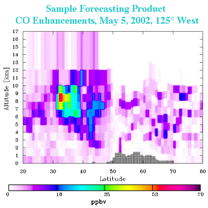 As well as in situ measurements, a major component of the ITCT 2002 project is the forecasting and modeling of long range transport. Meteorological and satellite data feeds (GOES-West and GMS5 geostationary infrared and water vapor) and a variety of 3D chemical transport models from regional to hemisphere to global scale were run to facilitate the flight planning. Forecasting activities included two three-dimensional tracer models used to forecast long-range transport and transformation of ozone and aerosols, their precursors and other trace chemicals, and particle dispersion models incorporating forecast wind fields which transport and disperse a passive tracer available daily.
- Satellite and Meteorological Product Archive (NOAA Aeronomy Lab)
- IAPS and GEOS-CHEM ITCT 2k2 Automatic Processing System (Harvard)
- CFORS-STEM Chemical weather FORecast System (University of Iowa)
- Tracer and trajectory forecasts and meteorological fields (Technical University of Munich)
- MM5-SMOG (UCLA)
- MOZART Model for OZone And Related chemical Tracers (NCAR)
- MATCH-MPIC Model of Atmospheric Transport and Chemistry (Max Planck Institue for Chemistry)
- Monterey Aerosol (Naval Research Laboratory)
|
|